Maps & Tools

Risk Finder
Climate Central's Surging Seas Risk Finder is designed to provide citizens, communities and policy makers in the U.S. with the tailored local information they need to understand and respond to the risks of sea level rise and coastal flooding in their own neighborhoods.
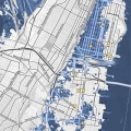
Risk Zone Map
This global interactive map — searchable by city or postal code — shows areas vulnerable to permanent submergence from sea level rise, or to flooding from sea level rise, storm surge, tides, and tsunamis, in different combinations.
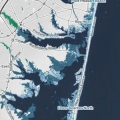
Ocean at the Door
Climate Central’s and Zillow’s Surging Seas: Ocean at the Door map shows areas, homes, and home value at risk of annual flooding or worse as sea levels rise, projected for the year 2050, assuming unchecked pollution and early instability of Antarctica. See the full report here.
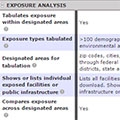
Sea Level Rise and Coastal Flood Web Tools Comparison Matrix
Compare the features and methods of the web-based sea level rise and coastal flood risk tools available for your U.S. state. Explore sea level and flood scenarios, analysis, technical specifications and more.