Using the Surging Seas free web tool within FEMA’s Community Rating System (CRS)
The Surging Seas CRS guide
We have identified many ways the Surging Seas web tool could be used to support activities that receive CRS credit/points within the CRS program through conversations with local CRS coordinators and implementers, and with FEMA CRS representatives. This guide provides step-by-step instructions on how to access information and downloads from the Surging Seas web tool that could be utilized within specific CRS activities in FEMA’s 2017 CRS Coordinator’s Manual.
- The 2017 edition of the CRS Coordinator’s Manual includes more opportunities for users to gain credit for considering the impacts of climate change and sea level rise on flood-related issues.
- Section 404 of the CRS Manual lists several activities that credit consideration of future sea level rise, including elements of Activities 410, 430 and 450.
- This guide demonstrates how Surging Seas can be used to gain points for activities 322c, 330, 342d, 352c, 412d, 422e, 432f, 432k, 452b, 512a, and 610.
- Our guide is listed on the reports section of the U.S. Climate Resilience Toolkit.
- Read about our CRS tools presentation with NOAA, ASFPM and TNC at Coastal GeoTools.
Sample pages from the Surging Seas CRS Guide
Community Rating System (CRS)
The National Flood Insurance Program’s (NFIP’s) Community Rating System (CRS) is a voluntary insurance rating program that recognizes communities for implementing floodplain management practices that exceed the Federal minimum requirements of the NFIP. In exchange for a community’s proactive efforts to reduce flood risk, policyholders can receive reduced flood insurance premiums for buildings in the community. To learn more, visit the CRS page at the FEMA.gov website.
Surging Seas public web tools, analysis, and downloads
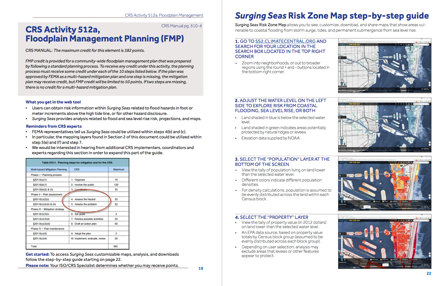
Surging Seas is a suite of free public web tools that help communities, planners, and leaders better understand sea level rise and coastal flood risks. Planners and stakeholders customize and download maps, slides, analysis, and projections from our Surging Seas Risk Zone Map and Risk Finder.
The Risk Zone Map is an interactive submergence risk map that shows areas vulnerable to coastal flooding from combined sea level rise, storm surge, and tides. It is based primarily on lidar-derived elevation data supplied by NOAA and includes layers for population density, social vulnerability, ethnicity, income, and property value.
The Risk Finder provides localized coastal flood and sea level risk projections, local reports and fact sheets, and exposure analysis of 100 demographic, economic, infrastructure and environmental variables.
Thousands of coastal stakeholders have downloaded Surging Seas maps and analysis. They use our web tools for planning, vulnerability and risk assessments, emergency preparedness efforts, research, policy analysis, public presentations, education and training. The tools are based on peer-reviewed science and listed as resources on the U.S. Climate Resilience Toolkit and NOAA’s Digital Coast portal. View case studies to learn more.
Additional Free CRS Tools and Resources
- ASFPM CRS Green Guide
-
NOAA’s How to Map Open Space for Community Rating System Credit and companion
GIS Workflow - The Nature Conservancy’s Community Rating System Explorer
- Coastal GeoTools