Commitment to Release Surging Seas for All Coastal States
Surging Seas 2.0
March 19, 2014
Concurrent with today’s launch of the federal Climate Data Initiative, Climate Central is proud to publish its own commitment to launching the next generation of its Surging Seas web tool and analysis for every coastal state in the U.S. Update: the tool has been launched so far for Alabama, California, Delaware, Connecticut, Florida, Georgia, Louisiana, Maine, Maryland, Massachusetts, Mississippi, New Hampshire, New York, New Jersey, North Carolina, Oregon, Rhode Island, South Carolina, Texas, Virginia, Washington and Washington, D.C.
Surging Seas helps local planners and policy makers with the tailored local information they need to understand and respond to the risks of sea level rise and coastal flooding. In addition, the Surging Seas website will continue to highlight and direct visitors to the federal, state, and local efforts underway to address the challenge of rising seas. The original Surging Seas was covered in over 800 stories nationwide, including NBC, CBS and PBS national broadcasts and front-page coverage in major newspapers; and has been used for testimony before the U.S. Senate.
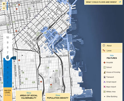
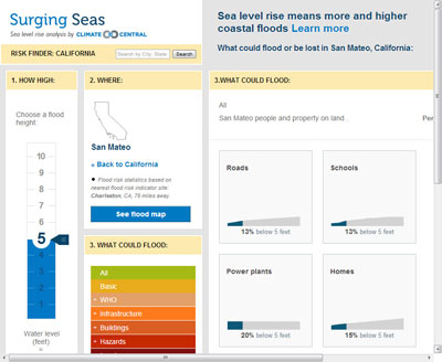
Surging Seas 2.0 includes the Risk Finder, an interactive data toolkit that shows populations, infrastructure, and assets exposed to coastal flooding aggravated by sea level rise. Our original Surging Seas materials included land, population, and housing at risk, tabulated by city, county, or state. The Risk Finder incorporates the latest, high-resolution, high-accuracy lidar elevation data supplied by NOAA and assesses exposure of countless infrastructure and other elements — from airports to road miles, from schools to hospitals to wastewater treatment plants — in order to allow users to tabulate and tally vulnerability by zip code, legislative districts, agency districts, planning districts, and other administrative units, from local through state through federal levels.
 |
 |
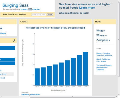 |
Risk Finder further intersects this analysis of physical vulnerability with an analysis of social vulnerability produced by our research partners so that users can identify with precision the most threatened communities. And Risk Finder presents localized projections for sea level rise and coastal flood risk in great detail, and according to a range of different models and assumptions.
The Risk Finder includes interactive maps, tables and figures of results, risk timelines, downloadable data, and accessible written analyses of social vulnerability. We will also be releasing an accompanying next generation online map.
We will launch our tool and map on a state-by-state basis. This effort is made possible thanks to a partnership with the Hazards and Vulnerability Research Institute (HVRI) at The University of South Carolina, and support from organizations such as the Kresge, Rockefeller, Island and Schmidt Family Foundations.
For more information please contact Dan Rizza at drizza@climatecentral.org