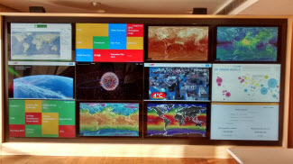
Case Studies
Tens of thousands of coastal stakeholders have downloaded Surging Seas maps and analysis. They use our web tools for planning, vulnerability and risk assessments, emergency preparedness efforts, research, policy analysis, public presentations, education and training. View Surging Seas Workshops and Events.
In addition, Surging Seas is listed as a resource on many government portals including the U.S. Climate Resilience Toolkit, NOAA Digital Coast, Climate.gov, National Weather Service, CA State Lands Commission, NHDOT, and numerous other state and municipal sites.
Maya Lin Uses Surging Seas Maps in Hudson River Museum Exhibition
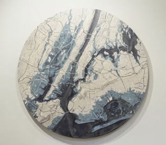 |
Maya Lin, an artist and environmentalist who is known for her large-scale environmental artworks such as the Storm King Wavefield, and whose works have focused attention on the natural world, used Climate Central’s sea level rise maps in an exhibition at the Hudson River Museum in Yonkers, New York, in the winter of 2018–19. Lin’s exhibition, A River Is a Drawing, comprised a series of 12 installations that traced the geography and environmental history of the Hudson River and its surroundings—from a sculptural outline of the river’s watershed to a vision of the Hudson’s historical biodiversity. Lin used Surging Seas maps to connect the Hudson’s past with its future. “I’m ending with climate change,” Lin told NYC-ARTS, “[with] maps from Climate Central that really predict [that], if we continue on the course we’re on, this is what will happen to Manhattan and the tristate area with two degrees centigrade rise, and four degrees.” |
South Florida Community Leader Educates Residents with Surging Seas
 |
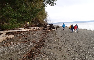
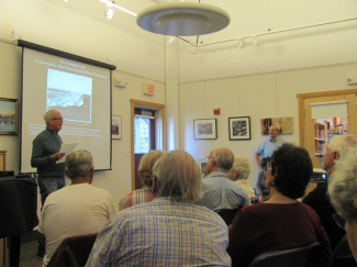
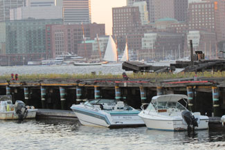
Scott Lewis, a community leader in South Florida is sharing Surging Seas maps and materials in his community meetings to raise awareness of the threat that sea level rise poses to his community. The group recently toured an area in East Hollywood to observe a King Tide flooding event (see picture). "This is a critical issue as sea level rise is such a threat to the area. The maps provide opportunities for our members and audiences to look at their residences and familiar landmarks in a way that we hope will impact their thinking about climate change." - Scott Lewis, Sea Level Rise Solutions community volunteer, Hollywood, FL |
Senator Whitehouse Uses Surging Seas Analysis on Senate Floor
 |
On February 23, 2016, U.S. Senator Sheldon Whitehouse displayed a graph from a Climate Central article and study on the floor of the U.S. Senate. The study concluded that from 1950 through 2014, two-thirds of coastal flood days in the U.S. would not have taken place if human-caused global sea level rise were subtracted. The full speech is covered on C-SPAN. |
Mason Conservation District Uses Surging Seas as a Communications Tool
|
|
An environmental specialist from the Mason Conservation District, an organization that provides non-regulatory technical and financial assistance to residents willing to voluntarily implement conservation actions in Puget Sound, WA, is using Surging Seas as a communications tool in its "Shore Friendly Mason" program. When interacting with Puget Sound shoreline homeowners, she uses Surging Seas maps to zoom in and visually display possible inundation risks for the properties being discussed. "Communicating the impacts of climate change using visual tools such as these interactive maps is extremely useful. The maps help people to "see" more concretely just how their shorelines could change under various scenarios in the future, and informs their property management decisions. The maps help me to frame the discussion about stewardship and to integrate both personal and ecological considerations into our conversation." - Karin Strelioff, Environmental Specialist, Mason Conservation District |
SC Small Business Chamber of Commerce Uses Surging Seas within Sea level Rise Task Force and Supreme Court Amicus Brief
|
|
The South Carolina Small Business Chamber of Commerce uses Climate Central’s Surging Seas Risk Finder as part of its Sea Level Rise Education Project (SCBARS.org). SCBARS used Surging Seas in talking with small business owners along the South Carolina coast about future sea level rise and the threat to the coastal tourism economy. Frank Knapp Jr., President and CEO of the Chamber, worked with his colleagues to successfully establish a Sea Level Rise Task Force for the cities of Beaufort and Port Royal, SC. The task force used Surging Seas Risk Finder to identify the geographic vulnerability and severity of future levels of rising seas, make presentations to local officials, small business owners and neighborhood associations, and develop resilience recommendations for areas of concern. View the Task Force's Final Report and Recommendations. According to Knapp, “Surging Seas has been an essential tool in our efforts. The street-level maps make presentations so much more effective and demonstrate the science behind our concern about rising seas. In addition, we used Surging Seas analysis when filing a friend of the court brief (an “amicus brief”) in support of the national Clean Power Plan, the strongest action to date for addressing climate change.” View press coverage in The Island Packet, the Charleston City Paper, and the PBS Newshour episode that features leaders from the South Carolina Small Business Chamber of Commerce and from Climate Central. |
Urban and Transportation Planner at San Francisco Recreation & Park Department
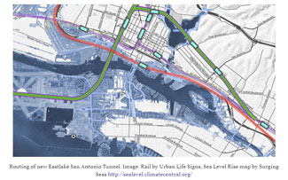 |
Brian Stokle, an urban and transportation planner, is advocating for ConnectOAKLAND and writes about transportation and sea level rise topics at Urban Life Signs. He used Surging Seas Risk Zone Maps and Risk Finder to inform his blog post on how to build Bay Area infrastructure that will last for 100+ years. "New infrastructure should be built to avoid the threat of future sea level rise by building on higher ground, not by building new fortified infrastructure. We can fortify existing infrastructure. My future grandchild may live to the year 2150. She will graduate from high school in 2070. So we're planning for her." - Brian Stokle, planner, San Francisco Recreation & Park Department |
The Exploratorium Incorporates Surging Seas into “Changing Shorelines” Exhibit
 |
The Exploratorium, a hands-on museum in San Francisco dedicated to exploring the world through science, art, and human perception, used Surging Seas map images and infrastructure analysis as the basis for its “Changing Shorelines” exhibit. The two-part exhibit first demonstrates how the San Francisco Bay formed over the 18,000 years since the last ice age, as glaciers melted and sea levels gradually rose and pushed through the Golden Gate to form the Bay estuary. It then maps the results of future sea level rise—between 2 and 6 feet above current levels—projected by scientists as a result of ongoing climate change. The visualization helps visitors see which areas might be flooded by such increases, including airports, highways and cities along the Bay shore. “The whole point is to get the public engaged in the conversation about the long history of the Bay and about how we might need to adapt as sea level rise accelerates.” - Susan Schwartzenberg, senior artist and developer of the Exploratorium’s Fisher Bay Observatory Gallery |
Brazil's Museum of Tomorrow uses Surging Seas in its "Observatory of Tomorrow" Exhibit
 |
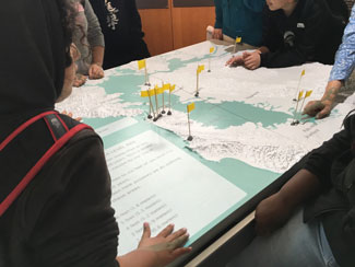
The Museu do Amanhã (Museum of Tomorrow, in Rio de Janeiro) invites visitors to look at the past, understand the changes of the present, and imagine what is possible in the future. An experimental museum, it presents cutting-edge, interactive content in a narrative that combines the accuracy of science with the expressiveness of art. In the "Observatory of Tomorrow", museum visitors experience Climate Central's Google Earth-based, 3D fly-over video created for Rio de Janeiro. This visualization allows viewers to see the stark difference in sea level rise for the city between a future of 4°C of global warming and one of 2°C, which could still be achieved if global efforts to control greenhouse gas emissions are successful. "Climate Central visualizations offer the opportunity to glimpse the potential consequences of sea level rise in coastal areas in the planet. It's an important tool from a scientific point of view and also to the understanding of choices we make every day that have an impact on climate change. To keep this perspective over the visitors' everyday lives is one of the functions the Museum of Tomorrow offers as an experience inside its walls - and we want to expand even more the potential of these tools." - Leonardo Menezes, Manager, Exhibitions and Observatory of Tomorrow |
MA Community Workshops Use Surging Seas in Public Discussions about Cape Cod's Future
 |
Dr. David Glassberg, Professor of History at the University of Massachusetts, Amherst, is using images and interactive maps within Surging Seas Risk Zone Map and Risk Finder for a series of four community workshops in Eastham, Wellfleet, Truro, and Provincetown, sponsored by Cape Cod National Seashore. As part of "The Changing Cape: A Conversation about Protecting Places that Matter in Our Communities,” local residents shared stories and viewed contemporary and historical photographs that highlight the dramatic social, economic and ecological changes on Cape Cod in the half-century since the Seashore was established in 1961. In combination, these changes threaten to alter or even obliterate storied landscape features and ways of life on the Outer Cape. Participants at these community conversations discussed the places on Cape Cod that they care about the most, the environmental threats these special places face, especially from global warming and sea level rise, and what actions might be taken to protect them for future generations. Other project partners include the Center for Coastal Studies, the Truro Historical Society, Save Truro Seashore, Pilgrim Monument and Provincetown Museum, Eastham Historical Society, the Association to Preserve Cape Cod, and Mass Audubon’s Wellfleet Bay Wildlife Sanctuary. |
Fairfield Museum and History Center Uses Surging Seas Materials for Exhibition
 |
The Fairfield Museum and History Center is using Surging Seas Risk Zone Map materials for an exhibition titled "Rising Tides". The exhibit is about regional shoreline history and planning for future sea level rise and flooding frequency. This timely exhibition explores the history of and future plans for coastal resilience through stunning photographs, artifacts and documents, and examines how climate change presents new challenges for the future. "Accessing authentic and real data, along with values and statistics, were key in order to present to the public a digestible yet scientific perspective on what the future holds for the coastal community of Fairfield, a town deeply affected by Hurricane Sandy in 2012." - Laurie P. Lamarre, Curator of Exhibitions, Fairfield Museum & History Center |
University of Miami School of Architecture Students use Surging Seas in Project
 |
Students from the University of Miami School of Architecture are developing designs to address the challenge that sea level rise poses to the city’s coastline as part of their broader study of urban planning. Jesse Alvarez, a student in the program is utilizing Surging Seas to conduct preliminary research for her studio's proposal. While some studios are adapting existing urban areas to sea level rise, hers is exploring the possibility of relocating a portion of the population from a region in South Florida to a region in Central Florida. Regardless of the solution each studio proposes, the exercise gives the students the opportunity to explore problems addressed in urban planning, either when planning a development for scratch or redesigning an existing urban area. A key part of the assignment is the justification upon which the proposals rest: in this case, how, when, and where sea level rise will affect various regions in South Florida. |
Climate Creatives uses Surging Seas in its Rising Waters project
 |
Climate Creatives uses Climate Central’s Surging Seas mapping tools in its Rising Waters project, which has been installed in over 15 locations, including in Panama. Climate Creatives is a social benefit organization that uses public art and art-making programs to engage and align people to act on climate, including storm preparedness. Climate Creatives’ public art project, Rising Waters, marks buildings and landscapes with lines to show future flood levels due to sea level rise and storms. Photo and video exhibitions of future U.S. and international installations will be traveling around the US to publicize impending flood impacts of climate change. "Every Rising Waters installation begins with a thorough look at the Surging Seas mapping tools, even in locations outside the U.S. The maps are incredibly helpful in giving us accurate data to convey to the public, and we really rely on them.” - Susan Israel, President of Climate Creatives and artist of Rising Waters |
View Surging Seas Events and Workshops
Have a story to tell about how you've used Surging Seas? Contact us.